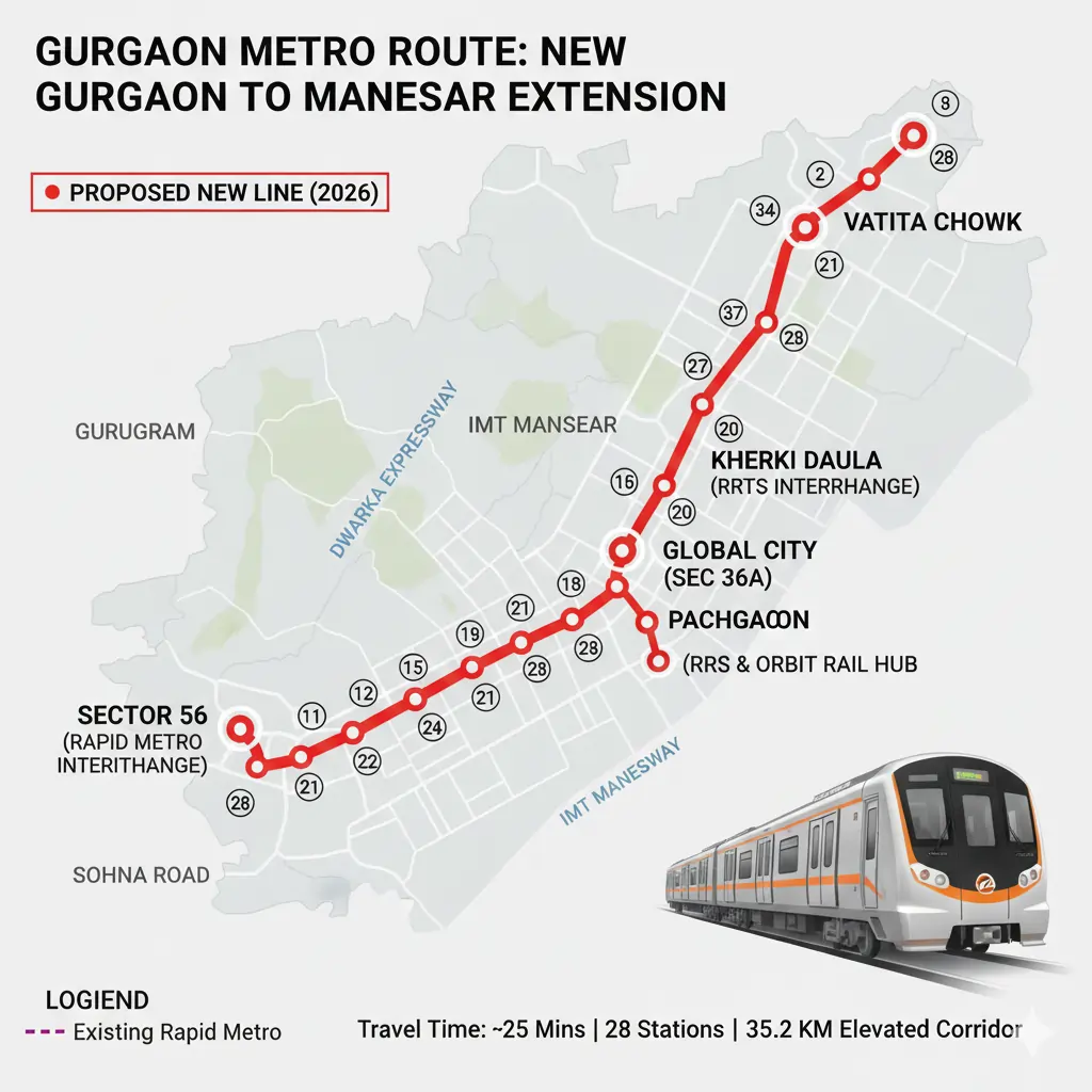
The Gurgaon metro is among the most radical infrastructure developments in 2026, which will connect the residential areas of the city to the industrial centre Manesar. The new Gurgaon to Manesar metro will cover a distance of 35.2 km, will open 28 elevated stations and will transform the commute in the region. This corridor is a significant move toward efficient and sustainable transport in the city, which is aimed at minimising the traffic use of NH-48 and the Southern Peripheral Road (SPR).
Introduction to the Gurgaon Metro Route.
Purpose and Vision
The Gurgaon metro line is supposed to increase the transportability between the major residential, commercial and industrial regions of Gurugram. It is the first extensive south-north corridor in the city, enhancing sustainable development of the city, and causing a decline in road jams.
Gurugram Metro Rail Limited (GMRL) Implementation.
The project was implemented by Gurugram Metro Rail Limited (GMRL) in partnership with the Haryana Government, with the emphasis on providing high-speed connectivity. The road will connect the Golf Course Extension Road to IMT Manesar and the future Pachgaon transit station.
Key Route Integration
The Gurgaon Metro route is linked to other metros (Rapid Metro and the Regional Rapid Transit System) so that one can interchange between them and enjoy one big city.
Essential Highlights and Project Information.
Project Specifications
Overall distance: 35.2 km (Fully Elevated)
Stations: 28
Estimated Cost: ₹8,500 Crore
Major Interchange Points
Other interchange hubs on the Gurgaon metro route are:
Sector 56: Rapid Metro connection.
Kherki Daula: Connected with Delhi-Alwar RRTS.
Pachgaon: RRTS and Orbit Rail multi-mode terminal.
Connectivity Scope
The Gurgaon to Manesar metro route is the new route with connections of Golf Course Extension Road, SPR, Sohna Road and New Gurgaon before reaching the IMT Manesar. It is an important east-west connection in the most densely populated and industrialised places of Gurugram.
Full list of Metro Route Stations in Gurgaon..
| Station # | Station Name | Key Neighborhoods & Landmarks |
| 1 | Sector 56 | Interchange with Rapid Metro |
| 2 | Sector 61 | Golf Course Extension Road Residents |
| 3 | Sector 62 | Pioneer Park, Heritage Village |
| 4 | Sector 66 | Emaar Marbella, M3M Golf Estate |
| 5 | Vatika Chowk | Interchange for Sohna Road & Faridabad Link |
| 6 | Sector 69/70 | Tulip Violet, Spaze Privy |
| 7 | Sector 75 | Southern Peripheral Road (SPR) Junction |
| 8 | Kherki Daula | Interchange with Delhi-Alwar RRTS |
| 9 | Global City (Sec 36A) | Future Central Business District (CBD) |
| 10 | Sector 88 | Near Dwarka Expressway |
| 11 | Sector 84 | New Gurgaon Residential Cluster |
| 12 | Sector 85 | DLF New Town Heights |
| 13 | Sector 89 | Pataudi Road Connection |
| 14 | Sector 86 | DLF Garden City Area |
| 15 | Sector 90 | Proximity to IMT Manesar Entrance |
| 16 | Sector 91 | Emerging Residential High-rises |
| 17 | M-15 (Manesar) | IMT Manesar Industrial Area |
| 18 | M-14 (Manesar) | Key Manufacturing Units |
| 19 | M-9 (Manesar) | HSIIDC Office / Corporate Hub |
| 20-27 | Intermediate Stops | Serving Manesar Sectors P1, P4, and P5 |
| 28 | Pachgaon | Terminal Point & Interchange with RRTS & Orbit Rail |
These metro stations within Gurgaon offer a smooth connectivity between residential places along Golf Course Extension Road and places of employment in IMT Manesar.
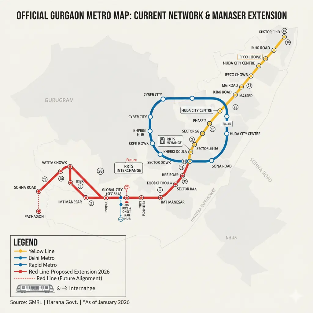
Examination of the Official Gurgaon Metro Map.
Strategic Design and Alignment
Gurgaon Metro Map clearly marks a route that does not involve any substantial traffic congestion. Along the way of the SPR, the road links up the new sectors, Global City and then the Manesar industrial estate.
Availability of Dwarka Expressway.
An interchange between the Metro route of Gurgaon and the Dwarka Expressway is available at a point close to Sector 101 and Basai, and enhances connectivity with regions in the city of Delhi and New Gurgaon as well.
Industrial and Commercial Reach.
The planned metro route will provide service to the manufacturing centres of IMT Manesar and link the business hubs of Gurugram, such as the Global City and Vatika Chowk.
Pros of Gurgaon Metro Route.
Fewer Congestions and Shortened Commute Times.
Using the Gurgaon metro route is a sustainable alternative to using roads, which means that commuting time between Golf Course Extension Road and Manesar will be reduced.
Sustainable Urban Mobility.
The metro connection between Gurgaon and Manesar removes the use of fuel and carbon emissions, which is in line with the environmentally friendly transport objectives of Gurugram.
Citywide Accessibility
Those who commute to work in Gurgaon metro routes stations can access more workplaces and education centres as well as shopping malls in the rest of the city.
Impact of Connectivity.
The Metro route to Gurgaon is crucial in easing the connection between Gurugram and the surrounding areas such as Delhi, Dwarka Expressway and Pataudi. Its strategic planning connects east and west routes, with the development being balanced across the city.
The project has close connections to SPR, Global City and Dwarka Expressway and assists the vision that Gurugram is a metropolis with global connections and an easy time commuting green.
Future Perspective and Urban Change.
The Gurgaon metro line of Gurugram is at the heart of the development of an international city. It facilitates the convenience of travel and environmentally-friendly development with the advanced digital ticketing, contemporary stations, and efficient systems.
The corridor connects residential areas, commercial and industrial areas, and this renders public transportation dependable, quick and has fewer environmental impacts.
Conclusion- Future of the Gurgaon Metro route.
The Gurgaon metro route is not only a transportation route but also a benchmark of the development of Gurugram. The new Gurgaon to Manesar metro will facilitate the development of the city’s eastern regions in tandem with the western industrial belt and will ensure a cleaner way of commuting.
The Metro route of Gurgaon, as indicated in the Gurgaon Metro Map, provides all residents of the city with high-speed, safe, and sustainable transportation, which is a new connectivity age in one of the most vibrant cities in India.
Top 5 Trending FAQs for Gurgaon Metro Route (2026)
1: How long is the Gurgaon Metro route?
The Gurgaon metro line covers about 35.2 kilometers with an origin station in Sector 56, Gurugram, to Pachgaon close to Manesar. The corridor has 28 completely elevated stations and links major residential, commercial, and industrial portions of the city.
2: What are the stations on the new Gurgaon to Manesar metro route?
The new Gurgaon to Manesar metro line has significant stations like Sector 56, Vatika Chowk, Kherki Daula, Global City, Sector 84, Sector 85, and IMT Manesar, and the route terminates at Pachgaon. These are stations of the Gurgaon metro route that allow direct access between the industrial centre of Manesar and the city parts.
3: When will the metro route of Gurgaon be ready?
According to Gurugram Metro Rail Limited (GMRL), the Gurgaon metro route is likely to be ready and functional by the end of 2026. Development is being conducted on key areas such as SPR, Vatika Chowk, and IMT Manesar.
4: What will the Gurgaon Metro Map do to improve connectivity to the city?
The Gurgaon Metro Map depicts a loop structure linking Golf Course Extension Road and Southern Peripheral Road (SPR), the global city, and Manesar. This orientation will ease the traffic across NH-48, give easier access to the Dwarka Expressway, and the connectivity across Gurugram will be balanced.
5: In what regions will the metro route in Gurgaon be of the most use?
Golf course extension road, Sohna road, SPR, and IMT Manesar are the areas that will be hugely benefited by the Metro route in Gurgaon. These areas will have fewer commuting periods, enhanced access, and more connections with big business and residential areas.