The longest national highway in India is a long path that covers thousands of kilometers and links different states, cultures, and landscapes in the country, which is situated in the northern parts and the other end in the southern parts of India. In this all-encompassing blog, we shall find out what makes this highway outstanding, how it is included in the grand scheme of other national highways in India, and also, we shall see some interesting facts, such as the smallest national highway in India.
The transport network of India is being supported by the national highways, which support the trade, tourism, and the movement of people throughout India. Of the list of national highways in India, however, there is one particularly- both in length- and in geographical importance. We shall now take a ride along the longest highway in India and find out more about the highway system that has the nation in motion.
𝗟𝗼𝗻𝗴𝗲𝘀𝘁 𝗡𝗮𝘁𝗶𝗼𝗻𝗮𝗹 𝗛𝗶𝗴𝗵𝘄𝗮𝘆 𝗶𝗻 𝗜𝗻𝗱𝗶𝗮?
The transportation grid of India consists of hundreds of major roads, which are referred to as national highways in India. The Government of India, through the Ministry of Road Transport and Highways (MoRTH), maintains and expands these highways.
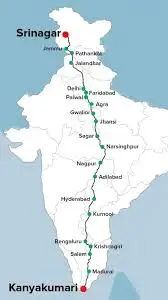
National Highway 44 (NH 44) is the longest national highway in India. It is around 4,113 kilometers long and is located between Jammu and Kashmir in Srinagar and Tamil Nadu in Kanyakumari, and basically it connects the far north and the far south of the nation. This makes NH 44 the longest among the national highways in India.
NH 44 passes through several states, such as:
- Jammu & Kashmir
- Punjab
- Haryana
- Delhi
- Uttar Pradesh
- Madhya Pradesh
- Maharashtra
- Telangana
- Andhra Pradesh
- Karnataka
- Tamil Nadu
This renders it as one of the most strategically vital transport corridors of the whole national highway system in India.
Also Read– Longest Expressways in India (2025)
𝗡𝗛 𝟰𝟰 𝗛𝗶𝘀𝘁𝗼𝗿𝗶𝗰𝗮𝗹 𝗕𝗮𝗰𝗸𝗴𝗿𝗼𝘂𝗻𝗱.
Before the redesignation of national highways in 201011, the current NH 44 was composed of many unconnected highways, such as old NH 1, NH 2, NH 3, and NH 7. These sections were merged, and they became one highway running north-south when India reorganized the highway numbering system.
This new reconfiguration not only made the logistical planning process easier but also enhanced connectivity between various parts of India. Consequently, NH 44 is a significant economic hub in the country in terms of national trade, tourism, and everyday economic activity.
𝗧𝗵𝗲 𝗜𝗺𝗽𝗼𝗿𝘁𝗮𝗻𝗰𝗲 𝗼𝗳 𝘁𝗵𝗲 𝗟𝗼𝗻𝗴𝗲𝘀𝘁 𝗡𝗮𝘁𝗶𝗼𝗻𝗮𝗹 𝗛𝗶𝗴𝗵𝘄𝗮𝘆.
The longest National Highway of India has several purposes:
𝗘𝗰𝗼𝗻𝗼𝗺𝗶𝗰 𝗖𝗼𝗻𝗻𝗲𝗰𝘁𝗶𝘃𝗶𝘁𝘆
NH 44 links agricultural regions, industrial belts, and metropolises like Delhi, Hyderabad, and Bengaluru. Being part of the extensive national highway system in India, it enables the rapid movement of goods and services at the interstate level. This saves on travel durations, aids supply chains, and enhances regional economies.
𝗖𝘂𝗹𝘁𝘂𝗿𝗮𝗹 𝗜𝗻𝘁𝗲𝗴𝗿𝗮𝘁𝗶𝗼𝗻
Passing by NH 44 is a cultural stroll around India. This highway runs through the mountains of Jammu and Kashmir to the tropical south, experiencing varying languages, traditions, and environments. It brings out the cultural richness that characterizes India.
𝗧𝗼𝘂𝗿𝗶𝘀𝗺 𝗮𝗻𝗱 𝗧𝗿𝗮𝘃𝗲𝗹
To tourists, the longest national highway in India, which serves as an epic road trip route. It provides leisure in hill stations, historic cities, religious sites, and scenic landscapes, which encourage domestic tourism in diverse regions.
𝗪𝗵𝗮𝘁 𝗶𝘀 𝘁𝗵𝗲 𝗻𝘂𝗺𝗯𝗲𝗿 𝗼𝗳 𝗻𝗮𝘁𝗶𝗼𝗻𝗮𝗹 𝗵𝗶𝗴𝗵𝘄𝗮𝘆𝘀 𝗶𝗻 𝗜𝗻𝗱𝗶𝗮?
And in case you are wondering how many national highways there are in India, this number may vary a bit every year due to additions, realignments, or reclassifications. But, according to the latest statistics (202526), the national highway system of India consists of more than 150.000 kilometers of roads, which comprise over 1.000 separate highways.
These highways are numbered systematically to enhance ease of navigation and planning. For example:
Highways with east-west direction have even numbers.
Odd numbers are given to north-south highways (such as NH 44).
India has an extensive network of national highways that are indeed essential to the national connectivity and economic effectiveness.
𝗜𝗻𝘁𝗲𝗿𝗲𝘀𝘁𝗶𝗻𝗴 𝗙𝗮𝗰𝘁 -𝘁𝗵𝗲 𝘀𝗺𝗮𝗹𝗹𝗲𝘀𝘁 𝗻𝗮𝘁𝗶𝗼𝗻𝗮𝗹 𝗵𝗶𝗴𝗵𝘄𝗮𝘆 𝗼𝗳 𝗜𝗻𝗱𝗶𝗮.
Although NH 44 is the longest national highway in India, India also has routes that are comparatively very short. The smallest national highway in India is often neglected, but the fact that even short segments of roadway can be significant is testified by it.
By 202526, the competitors on the shortest national highway are:
NH-766EE (Karnataka): Ranging at a distance of 4.27km, this is a road linking Hatikari to Bailey Kerryport.
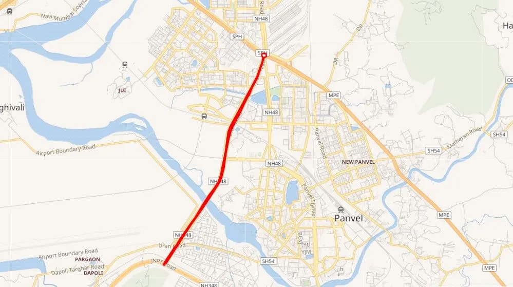
NH-548 (Maharashtra): This is an approximation of 5 km that connects Kalamboli with NH-348.
NH-118 (Jharkhand): It is another 5 km road that links Asanbani to Jamshedpur.
Historically, NH-47A (Kerala) used to be discussed as the shortest one, being approximately 5.9 km, the route between Kundanoor Junction and Kochi Port, but recent developments and reclassifications have taken over the title.
This comparison of the longest and shortest highways in India demonstrates the sheer variety of the list of national highways in India, as some of them are considered to have interstate extensions, and others to have very localized functions.
𝗠𝗮𝗷𝗼𝗿 𝗖𝗵𝗮𝗿𝗮𝗰𝘁𝗲𝗿𝗶𝘀𝘁𝗶𝗰𝘀 𝗼𝗳 𝘁𝗵𝗲 𝗡𝗮𝘁𝗶𝗼𝗻𝗮𝗹 𝗛𝗶𝗴𝗵𝘄𝗮𝘆𝘀 𝗦𝘆𝘀𝘁𝗲𝗺 𝗶𝗻 𝗜𝗻𝗱𝗶𝗮.
The national highway network has several objectives:
𝗙𝗮𝘀𝘁 𝗠𝗼𝘃𝗲𝗺𝗲𝗻𝘁 𝗼𝗳 𝗧𝗿𝗮𝗳𝗳𝗶𝗰
Roads such as NH 44 allow efficient transport without having to use the small roads in order to make long-distance transportation.
𝗦𝘁𝗿𝗮𝘁𝗲𝗴𝗶𝗰 𝗣𝗹𝗮𝗻𝗻𝗶𝗻𝗴
The defense logistics, trade corridors, and economic growth zones are considered in designing and maintaining roads such as NH 44.
𝗦𝗮𝗳𝗲𝘁𝘆 𝗮𝗻𝗱 𝗘𝗳𝗳𝗶𝗰𝗶𝗲𝗻𝗰𝘆
The recent improvements in the national highways of India are focused on safety aspects, such as dividers, lighting, bypassing heavy cities, and planned junctions.
𝗖𝗼𝗻𝗰𝗹𝘂𝘀𝗶𝗼𝗻
In short, NH 44, which is the longest national highway in India, does much more than only connecting the northern part of the country to the southern one. It is connected over a distance of over 4,000 kilometers, uniting economies, cultures, environments, and communities. The strategic significance of a properly designed road network is possible to understand by its role in the bigger picture of national highways in India.
In the meantime, the smallest national highway in India reminds us that even short roadways may have some significant purpose in a locality. The number of routes in the list of national highways in India is diverse, as the longest to the shortest route shows the different needs of transportation in India.
You want to take a road trip, you are researching the infrastructure of India, or you are just interested in knowing how this great network works; the longest and shortest highways in India give you an interesting insight into the development, planning, and connectivity of India.
𝗙𝗔𝗤𝗦
𝟭. 𝗪𝗵𝗶𝗰𝗵 𝗶𝘀 𝘁𝗵𝗲 𝗹𝗼𝗻𝗴𝗲𝘀𝘁 𝗻𝗮𝘁𝗶𝗼𝗻𝗮𝗹 𝗵𝗶𝗴𝗵𝘄𝗮𝘆 𝗶𝗻 𝗜𝗻𝗱𝗶𝗮?
The longest national highway in India is NH 44 that traverses between Srinagar and Kanyakumari and has a length of approximately 4,113 km. It links 11 states, and it is the largest north-south route in the country.
𝟮. 𝗪𝗵𝘆 𝗶𝘀 𝗡𝗛 𝟰𝟰 𝗳𝗮𝗺𝗼𝘂𝘀?
NH 44 is renowned since India has its most and the least populated parts connected to enhance trade, tourism, and transportation. Besides, it links big cities such as Delhi, Hyderabad, and Bengaluru.
𝟯. 𝗪𝗵𝗮𝘁 𝘄𝗮𝘀 𝗡𝗛 𝟰𝟰 𝗰𝗮𝗹𝗹𝗲𝗱 𝗲𝗮𝗿𝗹𝗶𝗲𝗿?
Previously, the NH 44 used to be a mixture of the old highways such as NH 7, NH 1, and NH 2. Following the 2010 renumbering, they became a single continuous north-south corridor.
𝟰. 𝗪𝗵𝗶𝗰𝗵 𝗶𝘀 𝗹𝗼𝗻𝗴𝗲𝗿, 𝗡𝗛 𝟳 𝗼𝗿 𝗡𝗛 𝟰𝟰?
NH 44 is longer than the old NH 7. Actually, NH 44 has taken over some parts of NH 7, becoming the longest national highway in India as a renumbered highway.
𝟱. 𝗪𝗵𝗮𝘁 𝗶𝘀 𝘁𝗵𝗲 𝘀𝗺𝗮𝗹𝗹𝗲𝘀𝘁 𝗻𝗮𝘁𝗶𝗼𝗻𝗮𝗹 𝗵𝗶𝗴𝗵𝘄𝗮𝘆 𝗶𝗻 𝗜𝗻𝗱𝗶𝗮?
As of 2025-26, the smallest national highway in India is NH 766EE in Karnataka, approximately 4.27 km in length. It links Hatikari with Bailey Kerryport.