Gurugram has grown way beyond its old city limits and the original office belts. New residential sectors, business districts, highways, metro lines and big mixed-use projects are reshaping how the city works. Planning this kind of growth needs more than clearing projects one by one. It needs a framework that decides where housing, roads, commerce, industry, public amenities and open spaces should come up.
That is exactly what the Gurugram Master Plan 2031 does.
Officially, this planning framework is called the Final Development Plan for the Gurugram-Manesar Urban Complex. Government mapping systems also list it as the Final Development Plan GMUC-2031, a dedicated master plan layer.
For residents, this plan explains why certain areas are set aside for housing or commerce and why some roads and infrastructure corridors show up on planning maps the way they do. For property buyers, it’s a good starting point to check the planned land use of an area before committing to a purchase.
What is the Gurugram Master Plan 2031?
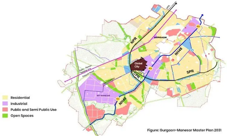
The Gurugram Master Plan 2031 is a long-term spatial plan for the Gurugram-Manesar Urban Complex. It lays out a structure for how the city should grow, instead of letting different pockets develop without any overall direction.
It covers things like:
- Residential zones
- Commercial development
- Industrial belts
- Transport and road networks
- Public and semi-public facilities
- Utilities
- Open and recreational spaces
- Environmentally sensitive and conservation zones
Here’s an important point to keep in mind. Just because a road, metro line or development shows up on the master plan map doesn’t mean it’s already functioning. A lot of what’s shown is planned land use or future infrastructure, and it still needs separate approvals, funding and construction before it becomes real.
That’s why this plan should be read as a planning document and not as a promise of guaranteed future development.
Gurugram Development Plan 2031 explained
The Gurugram Development Plan 2031 sets out how land within the planned urban complex can be used as the city keeps expanding.
A simple way to look at it is through three connected layers.
1. Land use
The plan marks out broad zones for different urban activities. Residential land is meant for housing, commercial areas hold offices, retail and other business uses, and industrial zones support manufacturing and related work.
Other categories cover the infrastructure a city needs to actually function, things like roads, public facilities, utilities and open spaces.
2. Transport structure
Roads on this plan aren’t just lines joining existing neighbourhoods. The transport corridors that are planned shape how new sectors will connect to the older parts of Gurugram and to nearby regions.
Major corridors like NH-48, Dwarka Expressway, Southern Peripheral Road and Central Peripheral Road need to be looked at alongside the sector where a property sits, not in isolation.
3. Supporting infrastructure
Housing growth without enough schools, hospitals, utilities, public facilities and transport puts pressure on whatever already exists. So the development plan also factors in these supporting needs as part of the larger urban picture.
The Haryana and GMDA mapping systems offer digital planning layers that let you check development plan details directly, instead of depending only on marketing maps put out by property companies.
Gurugram Master Plan 2031 Map: what does it actually show?
The Gurugram Master Plan 2031 Map turns the planning framework into something you can actually look at.
Rather than going through a long planning document, you can look at the map and understand how sectors, roads, land use zones and nearby development relate to each other.
The official GMDA mapping platform has a Final Development Plan GMUC-2031 layer built in. The TCP Haryana map service also carries its own DevelopmentPlan layer along with controlled areas, urban areas, licensed colonies and other related planning layers.
When you’re reading a master plan map, watch for these elements:
- Sector boundaries
- Existing and proposed roads
- Residential land use zones
- Commercial areas
- Industrial zones
- Public facilities
- Open spaces
- Controlled areas
- Transport corridors
- Environmental or conservation related zones
The single most important thing here is to check the land use designation, not just where a plot sits on Google Maps.
A piece of land might sit physically close to residential projects while carrying a completely different planning designation. What’s already built around a property doesn’t change its notified land use on its own.
Old Gurgaon
Covering the original sectors around 12 to 15, has mature infrastructure but almost no fresh land left to build on.
New Gurugram
Sector 81 to 95B is anchored by NH-48 and the Manesar link road, and it includes the Global City project carved out within it. Towards the Manesar side have become a key part of Gurugram’s outward growth. Housing here is closely tied to the major road corridors and the employment hubs nearby.
Dwarka Expressway corridor
Roughly sectors 102 to 115, has seen the fastest growth in the last two years now that the expressway connecting it to Delhi is fully open.
The metro plan also includes a proposed spur connecting the main Gurugram corridor to Dwarka Expressway. Project documents from HMRTC describe a 28.5 km corridor made up of the main Millennium City Centre to Cyber City stretch and a spur toward Dwarka Expressway.
Southern Peripheral Road and the sectors around it
Broadly sector 65 to 72 links Golf Course Extension Road to Sohna Road and has become one of the priciest micro-markets in the city.
For anyone researching property here, what matters more than it simply being a wide road is which areas and employment hubs it actually connects.
Sohna Road
Connected onward to the Delhi Mumbai Expressway. Worth flagging here: some Sohna facing parcels actually fall under a separate South Gurgaon planning authority rather than GMDA, so it pays to confirm which body governs a specific plot before assuming it sits under the Gurugram Master Plan 2031 at all.
Manesar
Manesar matters because Gurugram’s urban footprint stretches well past the traditional city centre. Industrial and employment activity around Manesar has driven demand for housing, commercial services and better transport links.
That’s why the relationship between Gurugram and Manesar is worth paying attention to when you’re studying the city’s long-term growth.
Gurgaon Manesar Master Plan 2031 and how it connects to Gurugram
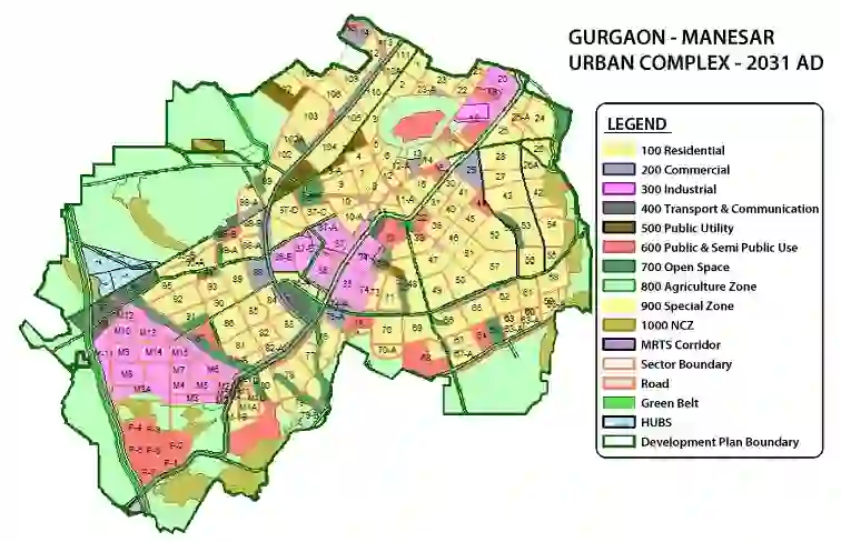
You’ll often see Gurgaon Manesar Master Plan 2031 and Gurugram Master Plan 2031 used as if they’re the same thing, but the naming can get confusing.
The formal planning area here is the Gurugram-Manesar Urban Complex. The GMDA mapping system officially lists the Final Development Plan GMUC-2031 as its master plan layer.
This matters because Gurugram shouldn’t be studied only as the established city built around Cyber City and Golf Course Road.
Its planned urban structure also brings in:
- New residential sectors
- Manesar’s industrial and employment zones
- Major transport corridors
- Expanding commercial areas
- Public infrastructure
- Future urban development zones
Looking at Gurugram and Manesar together as one connected system gives a much clearer sense of how the different parts of the region actually relate to each other.
How the plan ties roads and public transport together
Urban planning and transport go hand in hand.
A residential sector might have plenty of open land, but its long-term usability depends on how easily residents can reach workplaces, schools, commercial areas and public transport.
The planned Gurugram metro corridor is a good example of this link.
HMRTC’s current project documents describe a 28.5 km elevated corridor with 27 stations, made up of a 26.65 km main corridor running from Millennium City Centre to Cyber City, plus a 1.85 km spur toward Dwarka Expressway.
The revised DPR splits the main corridor into sections too: Millennium City Centre to Subhash Chowk, Subhash Chowk to Basai Village, Basai Village to Sector 5, and Sector 5 to Cyber City.
For urban growth, corridors like this matter because they can genuinely improve the connection between residential pockets and employment hubs.
But there’s a real difference between infrastructure that’s planned and infrastructure that’s actually built. Any property decision should weigh the current situation separately from what’s only proposed.
Why the master plan matters for real estate
The Gurugram Master Plan 2031 helps property buyers understand the bigger picture around a project.
Before buying a plot or property, it’s worth checking:
| Check | Why it matters |
|---|---|
| Land use | Confirms the planned use of the area |
| Sector location | Helps identify surrounding development |
| Road network | Shows existing and planned connectivity |
| Public facilities | Indicates planned supporting infrastructure |
| Nearby commercial areas | Helps understand employment and services |
| Environmental restrictions | Can affect development potential |
| Project approvals | Determines the legal status of the individual project |
None of this means a property automatically becomes more valuable just because it sits near a planned road or a future development zone. Prices depend on a lot of factors, including how fast infrastructure actually gets delivered, project quality, demand, supply and legal standing.
Think of the master plan as one piece of your property due diligence, not as a prediction of future returns.
What the master plan can’t tell you
A common mistake is expecting the development plan to answer every question about a property.
On its own, it cannot confirm:
- That a particular builder’s project is approved
- That a plot has a clean title
- That construction on a proposed road will begin by a set date
- That a future metro station will definitely open by a particular year
- That property prices will go up
- That a parcel can be used for whatever purpose the owner wants
Each of these needs to be verified separately.
The TCP Haryana mapping system, for instance, has separate layers for development plans, controlled areas, licensed colonies, regularised colonies and CLU boundaries.
That separation alone shows why looking at just the master plan map isn’t enough.
How to use the Gurugram Master Plan 2031 before buying property
Here’s a straightforward process to follow.
Step 1: Locate the property
Pin down the exact sector, village or parcel instead of going by a broad locality name.
Step 2: Check the planned land use
Use the relevant government planning map to find the designated land use category.
Step 3: Check the surrounding infrastructure
Look at both existing roads and proposed transport corridors, but keep the two categories clearly separate.
Step 4: Verify the project
If you’re buying into a plotted development, apartment project or commercial development, independently check the project’s approvals and registration wherever applicable.
Step 5: Check restrictions
Controlled areas, CLU requirements and other planning restrictions can limit what can legally be built on a parcel.
Step 6: Compare the plan with reality
Go visit the location. A map can show planned infrastructure, but it can’t tell you whether the road nearby is congested, whether public transport is actually convenient right now, or whether basic services are really available.
What’s actually built in 2026, and what’s still on paper
This is the part most articles on this topic skip, and it’s the one that matters most when you’re making a real decision.
The Dwarka Expressway, all 29 kilometres of it, is now fully open. The Haryana stretch opened in March 2024 and the Delhi stretch followed in August 2025. The Sohna Elevated Corridor has been running even longer, since July 2022, and already links up smoothly with the Delhi Mumbai Expressway.
Metro connectivity is finally picking up pace too. A new 28.5 kilometre loop from Millennium City Centre, earlier known as HUDA City Centre, to Cyber City via Old Gurgaon broke ground on 5 September 2026, with the main corridor targeted for completion around mid-2027. This is separate from the Delhi Metro’s Yellow Line and the existing Rapid Metro, and it will finally bring rail connectivity to long underserved areas like Old Gurgaon and Palam Vihar.
Global City is still some way off. Its first phase, covering roads, drainage and basic utilities across roughly 587 acres, is targeted for completion by December 2026, but that’s only the infrastructure. The full township, including actual built homes and offices, isn’t expected until 2035.
Meanwhile, some proposed roads, like the signal free elevated corridor planned along SPR near Vatika Chowk, are still stuck at the tendering stage after more than one round of delays. Treat a completed road and a proposed one very differently when comparing sectors, since the gap in timeline can run into years, not months.
The bottom line
The Gurugram Master Plan 2031 isn’t a marketing document it’s a legal one, and it’s still the plan in force in 2026 since its 2041 successor hasn’t been notified yet. Understanding the zoning colours, knowing which of the six corridors a sector falls under, and being clear on what infrastructure is actually built versus still proposed will tell you more about a property’s real potential than almost any brochure will. When in doubt, go back to the map, check the khasra number and verify the licence. That one habit alone avoids most of the disputes that come up around Gurugram property.
Frequently Asked Questions
What will be the estimated population of Gurgaon in 2031?
The Master Plan 2031 has been prepared for the Gurugram Manesar Urban Complex with an estimated population of 42.5 lakh. This is the number that the entire plan, including the roads, water supply, and more, has been based on.
What are the plans for Gurgaon metro in 2031 master plan?
The one with a big design is a brand new 28.5 km overground metro line that will run from Millennium City Centre (old HUDA City Centre) to Cyber City and then comes a spur to Dwarka Expressway. It was broken ground on 5th September 2026 and is anticipated to be ready by mid-2027. This is in addition to the old Yellow Line of Rapid Metro and Delhi Metro and should now make the areas such as Old Gurgaon and Palam Vihar accessible by train.
Does Gurgaon have a new master plan?
Not yet. A plan to shape the city for the next 20 years (Master Plan 2041) has been discussed, though it remains to be notified. This means the 2031 plan remains in effect and will apply to land use and zoning and approvals, as is the case now.
What will be done about the Gurgaon Manesar Urban Complex in the Gurgaon Master Plan 2031?
The plan is based on the premise of treating two areas – Gurugram and Manesar – as one integrated system. It includes new residential areas, industrial and employment areas of Manesar, important road corridors such as NH-48 and Dwarka expressway, growing commercial centres and public infrastructure to support the growth of the region.